Tavira’s Dragons & Their Relatives

Grove Koger

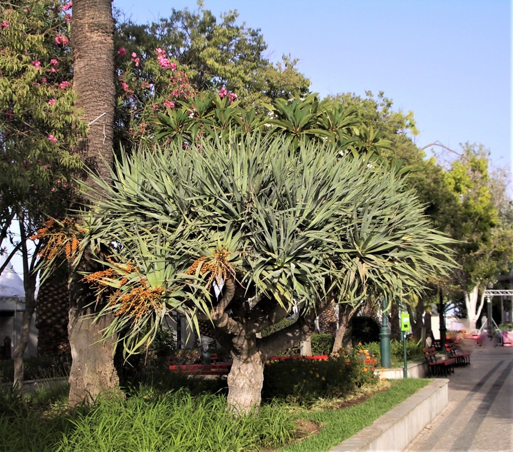
When we paid a second visit to the little southern Portuguese community of Tavira in 2023, the sights we planned to revisit included the town’s handsome dragon trees.

Growing in a little riverside park a few hundred feet from our hotel, the two trees probably go unnoticed by most of the town’s residents and visitors, but they’re a botanical delight for those who pause to look at them carefully or take time to learn more about them.

The dragon tree, or Dracaena draco, is native to southwest Morocco, the island nation of Cape Verde, the Spanish archipelago of the Canary Islands, and the Portuguese archipelago of Madeira. Scientists think that it was introduced to another Portuguese archipelago, the Azores, by Portuguese travelers from Cape Verde several centuries ago. Over time, the widely separated populations have developed into several subspecies.

Dragon trees are evergreens with pithy trunks, and can reach as much as 60 feet or so in height and 20 feet in circumference. They also have an unusual and distinctive growth pattern. After ten or fifteen years, the tree blooms and grows multiple branches, each one of which then grows more branches after another long period, with the result that its crown spreads wider and wider, as if the tree were growing upside-down. As John Mercer writes in Canary Islands: Fuerteventura (David & Charles, 1973), the “dense vivid green upon the pale grey, with a patch of the darkest shadow on the ground below, make a fresh, cool sight even amongst the other trees.”

The trees’ small fruit have a red resin that was once used in pigments and traditional medicines. The indigenous inhabitants of the Canary Islands, the Guanches and the Canarios, carved shields from the trees’ bark, and I’m sure took advantage of the shade that Mercer refers to.  

Reading about dragon trees in Visit Native Flora of the Canary Islands, by Miguel Ángel Cabrera Pérez (Everest, 1999), I’ve learned that a separate species of the tree has been identified on Gran Canaria Island and designated Dracaena tamaranae. This “new” species, found on the southern (and geologically oldest) section of the island, apparently shares characteristics with such East African species as Dracaena ombet and Dracaena schizantha, as well as an Arabian species, Dracaena serrulate. Botanists speculate that specimens may have reached the island millions of years ago in the Miocene period.

I don’t know when Tavira’s dragon trees were planted, but the oldest specimen on the Canary island of Tenerife is known as El Drago Milenario, and, at an estimated 1,000 to 5,000 years of age, it may be the oldest in the world. At 69 feet in height, with a circumference of about 66 feet, it may be the largest as well. That’s it you see above in a photograph by Mike Peel (www.mikepeel.net), reproduced courtesy of Wikimedia Commons. And should you find yourself on Tenerife, you can take a closer look by visiting the Parque del Drago, Icod de los Vinos, on the north shore of the island.

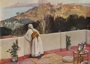
There was once another ancient specimen on the island, one examined by famed geographer and naturalist Alexander von Humboldt in 1799. Sadly enough, it was destroyed during a storm in 1867. According to John Mercer’s Canary Islanders (Rex Collings, 1980), the Guanches once “venerated” this particular tree, “seeing it as a protective spirit. Used by the Spaniards as a boundary post when dividing up the land amongst themselves in 1496 …, its well-authenticated measures were 75ft high, 78ft around the trunk.” Botanical artist Marianne North followed in Humboldt’s footsteps in 1875, discovering that the once-sacred tree had “tumbled into a mere dust-heap” with “nothing but a few bits of bark remaining.” However, she found “some very fine successors about the island,” one of which you see in her painting at the bottom of today’s post. And following in both sets of footsteps, A. Samler Brown added in the 1922 edition of Brown’s Madeira, Canary Islands, and Azores  (Simpkin) that “a cutting [was] still growing in one of the conservatories at Kew.”

The many people who stroll by Tavira’s dragon trees probably take them for granted, but the trees are members of a distinguished family, and worthy of our attention.

If you’d like to subscribe to World Enough, enter your email address below:

And if you’ve enjoyed today’s post, please share!

John Lavery’s Morocco

Grove Koger

March 20 is the birthday of Irish painter John Lavery, who was born in Belfast on this day in 1856. Although highly regarded in his day, he seems to have been forgotten in ours, which is a shame.

A society painter whose portraits rivaled those of John Singer Sargent and a friend of James McNeill Whistler, Lavery also served as a war artist during World War I, despite bouts of ill health and the injuries he suffered in an automobile accident during the course of a Zeppelin raid. And he excelled as an interpreter of Morocco, which he visited for the first time in 1891.

Lavery was taken with the region’s broad vistas and the quality of its light, and a number of works he painted on that first visit were exhibited later in the year at Goupil Gallery in London, along with examples on more familiar themes.

The artist was to return to Morocco every winter over the following years, with a break during World War I, and in time he even bought a residence with a hillside garden—Dar el Midfah—west of the Kasbah in Tangier, the famous “white city” perched at the western entrance to the Strait of Gibraltar. Lavery also set up a hilltop studio (whose entryway you see above) that provided him with an unparalleled view of the coast of southern Spain.

Lavery’s 1904 and 1908 exhibitions, the former at London’s Leicester Galleries and the latter at Goupil, emphasized Morocco even more, and included several views (an example of which you see above) over Tangier painted from the roof of the city’s Hotel Continental. Lavery is typically grouped with other European artists who produced paintings of North Africa and the Near East, but his quick, open brushwork sets him apart, and suggests that he was painting en plein air—outdoors—rather than working in his studio.

An interesting footnote to Lavery’s career involves his friendship with Scottish writer Robert Cunninghame Graham, who wrote an introduction to a catalogue issued in connection with Lavery’s Leicester Galleries exhibition. Cunninghame Graham is remembered in his own right as the author of a classic 1898 Moroccan travel account, Mogreb-El-Acksa.

If you’d like to subscribe to World Enough, enter your email address below:

And if you’ve enjoyed today’s post, pleas share!

The Mystery of Santa Cruz

Grove Koger

It’s Santa Cruz de la Mar Pequeña that I’m referring to, or Holy Cross of the Little Sea—a Spanish fort lying somewhere on the coast of Northwest Africa.

For Spain’s Africanistas, who supported a more aggressive colonial presence in Africa in the late nineteenth and early twentieth centuries, it was a reminder of their country’s early and illustrious activities on the continent.  

And that takes us back to 1468 and Diego García de Herrera, a Castilian knight who controlled several of the Canary Islands, including Fuerteventura. Operating under a concession from King Enrique IV of Castile, Herrera organized an expedition to build and garrison a modest fortress and trading post—Santa Cruz de la Mar Pequeña—on the African coast that year. The fort took its name from a nearby lagoon known as the Mar Pequeña, or “Little Sea.” 

Herrera and his compatriots hoped to take advantage of the trans-Saharan trade, establish a fishing station, and, as they had decimated the Canaries’ indigenous population, procure slaves to work on the islands’ sugar cane plantations.

When Herrera died in 1485, Santa Cruz was abandoned, only to be rebuilt by Alonso Fajardo in 1496 as a direct possession of the Castilian monarchy. It was attacked two years later by Portuguese troops (apparently in league with Herrera’s widow), and although it survived, its demise finally came in 1524 when it was sacked by forces of the Saadi dynasty of Morocco. By then, Spanish colonial interests had shifted to the New World, and the country’s attention returned to Northwest Africa only in the mid-1880s, when Spain began establishing modest trading posts and forts along the coast of what would become the colony of Rio de Oro.

This image has an empty alt attribute; its file name is santa-c-4.jpg

However, the exact location of Santa Cruz de la Mar Pequeña had long since been forgotten. Although there was little reason to think so, Spanish authorities decided that the site lay near the coastal Moroccan settlement of Sidi Ifni, northeast of Rio de Oro, and in light of this dubious identification, Spain eventually established the tiny colony of Ifni there.

More recently, researchers have finally identified the ruins of the fort, farther to the southwest and opposite Fuerteventura, near the extensive Naila Lagoon in what’s now Morocco’s Khenifiss National Park. Dr. Mariano Gambín García describes the discovery in his book La Torre de Santa Cruz de la Mar Pequeña (Le Canarien, 2015).

The image of the top of today’s post (by D.C. Alvarez Dumont) appeared in “Intereses Españoles en Marruecos” in the weekly Madrid periodical La Ilustracion Española y Americana XXXII (1882), and makes what was then the accepted identification of Sidi Ifni as the site of the fort. Its caption reads (in translation) “Mouth of the Ifni River, where Santa Cruz de Mar Pequeña is located. Section of the coast. Customs of the Berbers. Outpost of the caravan of Timbuctu, parading before the ruins of the tower of Herrera (Burg-el-Rumi). Sidi Ifni shrine and graveyard.” The postage stamp from Spanish Sahara (as Rio de Oro eventually became known) was issued in 1961, and the map of the Canary Islands and the nearby African coast dates from 1823. The striking photograph of the lagoon in the Khenifiss National Park is by TarfayaMedia and is reproduced courtesy of Wikimedia Commons under the Creative Commons Attribution-Share Alike 2.0 Generic license.

□□□

If you’ve enjoyed today’s post, please share!

La Isla Perejil & Operation Romeo-Sierra

Grove Koger

When sovereignty and national pride are involved, even the tiniest speck of land—the smallest rock—can take on exaggerated importance.

That’s the lesson of Perejil Island, or Isla Perejil (as it’s known in Spain), or Jazirat Laila (as it’s known in Morocco). The word “perejil,” in case you’re wondering, is Spanish for “parsley,” a wild variety of which apparently grows there.

Perejil is about a quarter of a square mile in size, and although it lies only 270 yards from the African mainland, it’s been Spanish territory for nearly four hundred years. Spain’s Iberian neighbor, Portugal, took possession of the rocky islet in 1415 from what’s since become Morocco. At the time, Spain and Portugal were ruled by a single sovereign, although, a little confusingly, they remained separate countries. That ended in 1640, when this Iberian Union, as it was known, came to an end. One of the upshots of the break was that Perejil, along with Ceuta, a port on the nearby coast of Africa that Portugal had also seized in 1415, eventually became Spanish. Are you with me so far?

In any case, Perejil, which is administered from Ceuta, has no permanent human inhabitants, although in the opening years of the twenty-first century a Moroccan woman, Rajma Lachili, was routinely grazing her goats on the islet and smugglers and refugees were making occasional use of it. Whether the latter situation was particularly serious in 2002 isn’t clear, but the issue served as a pretext for Morocco to land a dozen soldiers on Perejil on July 11 of that year. They raised the Moroccan flag and set up a rudimentary base, but when Spain protested vehemently, as of course Morocco knew it would, the latter country replaced its soldiers with marines in what was apparently meant to be a conciliatory gesture. However, the switch was to no avail.

On the morning of July 18, Spain’s navy and air force launched Operation Romeo-Sierra, which involved landing a contingent of commandos on the island from helicopters and taking the  Moroccans prisoner. Spanish fighter planes provided air cover, while two Spanish patrol boats approached a Moroccan gunboat that was anchored nearby to discourage it from taking action. There were no casualties.

After a blusterous round of charges, counter-charges, and negotiations, Morocco eventually acknowledged Spanish sovereignty over the islet. If anyone profited from the affair, it may have been Ms. Lachili, who had been paid to prepare food for the hapless Moroccan troops. On the other hand, the woman subsequently demanded compensation from Spain for having killed four of her animals. The Spanish defense ministry denied the charge, saying that its men had found the remains of two goats that had apparently been butchered and eaten by the Moroccans. The fate of the other two animals, assuming they had ever actually existed, is unclear.

The squabble over Perejil is just one of several ongoing disputes over territory in the western Mediterranean and the Strait of Gibraltar, many of which have been violent. The British territory of Gibraltar, which shares a border three-fourths of a mile long with Spain, has long been claimed by the latter country and has been the object of protracted sieges and blockades. Spain, on the other hand, possesses two ports and several islets lying along the northern coast of Morocco, including Ceuta and Perejil. These Plazas de Soberanía, as they’re known, have been Spanish territory for centuries and—given the contentious issues I mentioned in my opening paragraph—are likely to remain so for centuries more. Likewise, Gibraltar will almost certainly remain British.

□□□

The photograph at the top of today’s post was taken by Richard White and is reproduced courtesy of Flickr Commons, while the map was produced by Kimdime69 and is reproduced courtesy of Wikimedia Commons. The cover of the Revista Espanola de Historia Militar is scanned from my collection, and features a photograph taken from one of the Eurocopter Cougars involved in the Spanish operation.

Hanno’s Great Voyage South

Grove Koger

Hanno the Navigator was a Carthaginian seaman living in the fifth century BCE, and what little we know about him we know in a tenuous, roundabout way.

According to Roman author Pliny the Elder (c.23-79), Hanno hung a report in a temple in Carthage (in what’s now Tunisia) of a voyage he had taken down the Atlantic coastline of Africa. Beside his report, he hung three skins, a detail we’ll get back to later. The Navigator’s text was subsequently copied about 400 BCE in an inscription in another Carthaginian temple, and then translated into Greek and copied during the Middle Ages in two Byzantine manuscripts, Codex Palatines Graeus 398 and Codex Vatopedinus 655. Next, Swiss polymath Conrad Gessner translated the text into Latin in 1559. Along the way, portions of the narrative have been lost and others may have been corrupted, but in any case, it’s been given the title Periplus, which means “coastal voyage.”

This image has an empty alt attribute; its file name is hanno-2.jpg

Hanno’s mission apparently involved colonization as well as trade, and was probably based on at least some previous knowledge of the coast, as he is said to have sailed with a fleet of 60 penteconters (50-oared ships) and some 30,000 men and women. While these numbers may well be exaggerated, they certainly suggest a large expedition. The Navigator apparently established several settlements on the coast of what’s now Morocco, including Thymiaterion (Kenitra or Mehidy, at 34°15’N; that is, north latitude) and Acra (possibly Agadir, at 30°25’N). The river he refers to as the Lixos may have been the Drâa, which flows into the Atlantic opposite the Canary Islands at 28°45’N.

Hanno probably ventured farther south. But just how far? There’s speculation that he may have reached the Gambia River (13°28’N), south of which the African coastline shifts noticeably to the southeast. It’s at this point that we need to consider two tantalizing mysteries in the text of the Periplus.

In Section 13 of the work, as translated by Wilfred H. Schoff in 1913, we read that Hanno’s ships “came to an immense opening of the sea, from either side of which there was level ground inland; from which at night we saw fire leaping up on every side at intervals, now greater, now less.” Fire shows up again in Section 15, where the expedition “passed by a burning country full of fragrance, from which great torrents of fire flowed down to the sea. But the land could not be come at for the heat.” In the next section, the ships “sailed along with all speed, being stricken by fear.” After rowing four more days, the Carthaginians “saw the land at night covered with flames. And in the midst there was one lofty fire, greater than the rest, which seemed to touch the stars. By day this was seen to be a very high mountain, called ‘chariot of the Gods.’”

This “chariot” could have been Mount Cameroon, which lies at 4°13’N near the Gulf of Guinea in what’s now the nation of Cameroon. It’s known in the local dialect as Mongo ma Ndemi, or “Mountain of Greatness.” At 13,435 feet high, it’s easily the highest point in the region. And it’s an active volcano. In fact, it’s part of a chain of volcanic islands nearly a thousand miles long known as the Cameroon Line that includes the islands of Bioko, Príncipe, São Tomé (which lies practically on the equator), and Annobón (Pagalu).

This image has an empty alt attribute; its file name is hanno-4.jpg

Another mystery involves the skins that Hanno hung up beside his report. The final section of his report refers to an island with a lake, within which there is another island “full of savage men. There were women too, in even greater number.” These savages had “hairy bodies,” and although the men escaped “by climbing the steep places and defending themselves with stones,” the Carthaginians “took three of the women,” whom they killed and skinned when the creatures “bit and scratched” and “would not follow.” In his translation, Schoff refers to these creatures as “Gorillæ,” but the animals we call gorillas don’t throw stones. On the other hand, chimpanzees do, and one population of the apes is found in West Africa just south of the Gambia River. Two others can be found near Mount Cameroon.

Taken together, these clues suggest that Hanno’s fleet may have reached the westernmost point of the African continent, which lies just north of the Gambia River, or even approached the equator. On the other hand, most modern authorities doubt that the Navigator’s fleet could have returned if it had sailed past Cape Bojador (at 26°7’N), as the currents and winds would have been against them. Although the Carthaginian ships were equipped with fifty oars apiece, rowing against the currents for any distance would have been a Herculean task.

Making our analysis even more difficult, Hanno may have altered the descriptions of the places he visited in order to throw off competing traders from other countries. We’ll probably never know the real extent of his travels, but—based on the clues in the Periplus—it seems likely that he or his fellow countrymen possessed at least fragmentary knowledge of tropical Africa.

□□□

The quotations in today’s post are taken from The Periplus of Hanno; A Voyage of Discovery down the West African Coast, by a Carthaginian Admiral of the Fifth Century B.C.; The Greek Text, with a Translation by Wilfred H. Schoff (Philadelphia: Commercial Museum, 1913). Surprisingly little about Hanno has been published in English; the most useful source I’ve found is the book Carthage: A History, by French historian and archaeologist Serge Lancel, translated by Antonia Nevill and published by Blackwell in 1995.

□□□

The image at the top of today’s post is a 1754 map illustrating Hanno’s possible route down the coast of West Africa, with the island of São Tomé shown, slightly out of its true position, on the equator. The second image shows a Phoenician ship on a coin minted during the reign of King Tennes of Sidon, who ruled in the 4th century BCE. (Carthage was originally a Phoenician colony.) The third is an 1893 wood engraving of the mouth of the Drâa River, while the fourth is a map of the Cameroon line, reproduced from Wikipedia under the terms of the GNU Free Documentation License, version 1.2.

Paul Bowles’ Lyrical History

Grove Koger

Today’s post is devoted to a late work by Paul Bowles, who was born December 30, 1910, and died November 18, 1999. Most of the text is drawn from a review I published in the November/December 1987 issue of The Bloomsbury Review.

□□□

Paul Bowles: Points in Time (Ecco P., 1982)

Was it Gertrude Stein or Alice B. Toklas who first sent the young American Paul Bowles to Morocco? Bowles’ own accounts vary. In any case, he spent several months there in 1931. By 1934 he had visited North Africa several times, and in 1947 he returned to Morocco for good. Along the way the accomplished composer who had studied with Aaron Copland became an accomplished writer, and, before long, America’s most distinguished expatriate.

Not unexpectedly, Bowles’ adopted home figures prominently in his work. Four of his five novels are set in Morocco or neighboring Algeria, including his most famous, The Sheltering Sky (1949), as well as most of his many stories.

In 1982, Bowles published a stunning new work that conveyed the inner experience of his adopted home better than any of his previous writings and brought together the composer and writer. But its publication was greeted with virtual silence; perhaps critics found the book too brief or elusive to get an easy grip on.

Points in Time consists of eleven sections, one of them all of sixty words long and a few the length (and shape) of short stories, arranged chronologically from the earliest times to the day before yesterday. The collection opens with a glimpse of Morocco’s Atlantic coastline as it must have looked to Hanno, the Carthaginian traveler who sailed through the Strait of Gibraltar and down the West African coast about 500 B.C.E. Many of the subsequent episodes explore the relationship between Moslems, Jews, and “Nazarenes,” or Christians.

One of the best pieces, which is apparently based on a true incident, concerns one Andrew Layton, an English exporter living in the windy seaside town of Essaouira two centuries ago. Layton becomes involved in a fracas with some farmers and in anger strikes a woman in the face with his whip, dislodging two of her teeth. All parties are called before the Sultan in Marrakech, where Layton straightforwardly admits the crime and the farmers successfully press their demand for “precise retaliation.” What follows is pure Bowles:

Layton “had the presence of mind to ask that the teeth to be pulled be two molars which recently had been giving him trouble. The complainants agreed to the suggestion. Back teeth being larger and heavier than front teeth, they felt that they were getting the better of the bargain.

“The operation went ahead under the intent scrutiny of the villagers. They were waiting to hear the infidel’s cries of pain. Layton, however, preserved a stoical silence throughout the ordeal. The molars were washed then presented to the claimants, who went away entirely satisfied.”

Impressed with Layton’s composure, the Sultan befriends him, hoping that eventually Layton might become British Consul in Marrakech. But no, he will stay in Essaouira. “He had got used to the wind, he said.”

He had got used to the wind …

Disputes among people of various religions and nationalities, among the colonizers and the colonized, are usually settled less satisfactorily. “At night in the courtyards of the Rif, grandfathers fashion grenades. Each rock in the ravine shields a man. The Spaniard in the garrison starts from sleep, to find his throat already slashed.”

Ecco Press promoted Points in Time as a novel, a pretty elastic term that nevertheless is misleading in this case. Points in Time resembles nothing so much as a suite, a form favored by Bowles in his composing days. (There’s even a translation here of an anti-American song popular n Morocco in the 1950s.) Every word counts, and each is carefully chosen so that the effect is precisely musical, however varied the movements. In Points in Time, Paul Bowles the composer has returned to collaborate with Paul Bowles the writer to produce their most important work, a resolutely unromanticized suite morocaine drawn from that country’s extravagant history. It was worth the wait.

□□□

The jacket of Points in Time was designed by Cathy Saksa, and the photograph of Paul Bowles was taken in Tangier. The map of Morocco is by 16th-century cartographer Abraham Ortelius, and is reproduced in black and white on the endpapers of Points in Time; north and the southern coasts of Spain and Portugal are to the right.

With George Borrow on the Peninsula

Borrow - Bible - 3

Grove Koger

Today’s selection from my book When the Going Was Good deals with the best-known book by English writer George Borrow, who was born July 5, 1803.

□□□

The Bible in Spain; or, The Journeys, Adventures, and Imprisonments of an Englishman, in an Attempt to Circulate the Scriptures in the Peninsula (London: John Murray, 1843)

The Byronic George Borrow, so famous during his lifetime, so thoroughly forgotten today, is surely ripe for rediscovery. A student of Roma (gypsy) life and lore, he cast himself as a scholar adventurer, providing enthusiastic readers with fictionalized accounts of his early years and travels with the Roma in Lavengro (1851) and The Romany Rye (1857).

Borrow - Portrait 2

Borrow was an apostle of the open road, and made a marathon walk of 27.5 hours in 1833 from his home in Norwich to London, where he applied for a position with the British and Foreign Bible Society. Posted first to Russia, he was next sent to Portugal and Spain (for Borrow “the land of old renown”) to print and distribute copies of the New Testament, a work then proscribed by the Catholic Church. Borrow arrived in Lisbon, Portugal, in late 1835, revisiting London in 1836 and 1838 but otherwise remaining in the Iberian Peninsula and nearby Morocco until 1839, when official Spanish opposition drove him home.

Borrow based The Bible in Spain to a large extent on his letters to the Bible Society. While it reads like a breathless catalogue of picaresque adventures—brawls and narrow escapes abound—the book seems on the whole to be a truthful document. The Iberian Peninsula was then in the throes of the political turmoil precipitated by the Napoleonic wars, and Borrow supplies some suitably grotesque anecdotes of military savagery. Not surprisingly he is also virulently anti-Catholic. As to his ostensible mission, Borrow admits to accomplishing “but very little,” yet pronounces the period “the most happy years of my life.”

Borrow - Toledo - Etched by Manesse

If you’re looking for a good edition of The Bible in Spain, the Macdonald edition (London, 1959) includes notes by Peter Quennell. The Everyman’s Library edition (London: Dent; New York: Dutton, 1961) includes an introduction by Walter Starkie, a fellow student of the Roma. The Century edition (London, 1985) includes an introduction by Ted Walker.

Borrow’s other works include The Zincali; or, An Account of the Gypsies of Spain, with an Original Collection of Their Songs and Poetry, and a Copious Dictionary of Their Language (1841); and Wild Wales: Its People, Language, and Scenery (1862).

And if you’d like to know more Borrow, see Michael Collie, George Borrow, Eccentric (Cambridge: Cambridge University Press, 1982); Robert R. Meyers, George Borrow (New York: Twayne, 1966); and David Williams, A World of His Own: The Double Life of George Borrow (Oxford: Oxford University Press, 1982).

□□□

The image at the top of today’s post is a scene of Segovia from the 1843 Murray edition, engraved by Georges-Henri Manesse after a sketch by A. H. Hallam Murray. The portrait of Borrow is by an unidentified artist and is reproduced from the 1920 Dent edition of The Life of George Borrow by Clement K. Shorter, while the bottom image is a view of Toledo engraved by Manesse after a sketch by an unknown artist.

□□□

If you’ve enjoyed today’s post, please share!

Vieuchange’s Forbidden City

Smara

Grove Koger

Until I complete a second edition of When the Going Was Good, I plan to post revised and updated entries. Today’s deals with Smara, the Forbidden City by French writer Michel Vieuchange, who was born on August 26, 1904, and died in 1930.

□□□

Smara, the Forbidden City: Being the Journal of Michel Vieuchange While Travelling among the Independent Tribes of Southern Morocco and Rio de Oro (Chez les dissidents du Sud marocain et du Rio de Oro, Smara, carnets de route de Michel Vieuchange; Paris: Plon, 1932)

Influenced by such revolutionary spirits as Arthur Rimbaud and Frederic Nietzsche, young Frenchman Michel Vieuchange came to scorn the literary vocation he had aspired to. Turning instead to a life of action, he conceived the quixotic scheme of visiting Smara, a settlement he had learned about during military service in Morocco. Located in the Saguia el-Hamra region of what was then Spanish Sahara (and is now the Moroccan-occupied territory of Western Sahara), Smara had been founded by Sahrawi resistance leader Cheikh Ma el-Ainin in 1898, only to be abandoned by him a decade later after a military reversal. The French forces that reached it in 1913 found it deserted and laid waste to much of it, including its library.

Vieuchange began his journey from French Morocco one night in mid-September 1930. As Christians traveling in the Sahara were subject to almost certain death, he disguised himself at first as a woman and eventually hid himself in a basket hung from a camel. The physical rigors of the journey told on him immediately, and he came to realize that he was at the mercy of deceitful and abusive guides. He learned to eat locusts and drink “putrid water.” Yet he urged himself ever onward: “My only objective—to keep going.” Vieuchange’s small party reached Smara in early November, but his guides allowed him only three hours to wander the ruins of the “dead city.”

On his return journey, Vieuchange contracted dysentery and died in late November, converting, like Rimbaud before him, to Catholicism on his deathbed. His fragmentary, frequently harrowing journal was published two years later, edited and introduced by his brother Jean. In his eloquent preface, French poet Paul Claudel spoke of Vieuchange’s determination to reach Smara (and by extension death—and God), asserting that “never lover hastened to trysting-place at the bidding of his mistress with a heart so impatient.”

□□□

Editions: The English translation is by Fletcher Allen. Editions in French and English contain an introduction, an epilogue and appendices by Vieuchange’s brother as well as a preface by Paul Claudel.

003 (1)