
Grove Koger
One of the difficulties that travelers on the eastern shores of the Adriatic Sea have faced over the centuries has involved proceeding northward from points on the mountainous Pelješac (pehl-yeh-soks) Peninsula.
Because the 40-mile-long peninsula stretches northwestward from southern Croatia, it’s been necessary to head down the peninsula to the little community of Ston if you’re proceeding up the coast to, say, Split or Rijeka. Since the breakup of the former Yugoslavia, you’ve also had to cross the so-called Neum corridor, a 12-mile stretch of the nation of Bosnia and Herzegovina, before re-entering Croatian territory. That in itself hasn’t been a problem, although Maggie and I have learned to keep our passports handy in case of tightened security.

However, even that minor inconvenience has been eliminated, along with the greater one, thanks to the new 7,887-foot Pelješac Bridge, which officially opened July 26, becoming the second longest structure of its kind in Europe. Designed by Slovenian engineer Marjan Pipenbaher, it’s made up of 13 spans in all, with several of them supported by cables.
The project was carried out by China Road and Bridge Corporation of Beijing, and was co-funded by the European Union. Construction began in July 30, 2018, so the work took just slightly less than four years to complete.
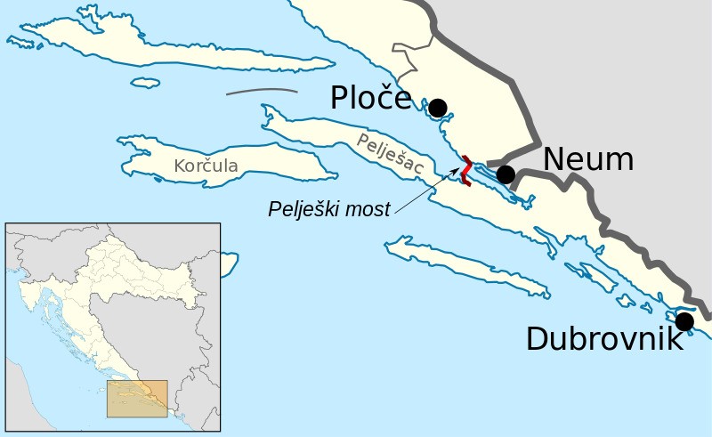
Early on, a dispute arose between Croatia and its neighbor, since the bridge might be seen as an obstacle to Bosnia and Herzegovina’s access to the sea. Although Neum doesn’t have sophisticated port facilities at the moment, Croatia raised the projected clearance of the bridge between two of its central pylons to 180 feet. I don’t think that the dispute has been officially resolved at the time of writing, and may never be, but Croatia has declared that the Croatian port of Ploče, which lies northwest of the Neum Corridor, will remain open to larger ships handling cargo for Bosnia and Herzegovina.
For what it’s worth, I’ll mention that taxonomically minded geographers have categorized southeastern Croatia as a semi-exclave, meaning that it would be an actual exclave of Croatia (a part of a political unit completely surrounded by another unit or units) if it didn’t have a coast open to international waters. But I wonder— With the completion of the Pelješac Bridge, has the area become an ex-semi-exclave? A semi-semi-exclave? Probably not, but it’s fun to think about.
□□□
The photograph at the top of today’s post was taken by Ponor, and the map at the bottom is the work of Pechristener; both are reproduced courtesy of Wikimedia Commons. The second photograph, of the dramatic coast of the Pelješac Peninsula, is ours, and was taken from our room on the island of Korčula in 2005.
□□□
If you’ve enjoyed today’s post, please share!
